Why InetSoft's Business Intelligence Dashboards?
Are you researching business dashboard options? There certainly is no shortage of solutions to consider. InetSoft offers business dashboards as a component of its BI software platform Style Intelligence.
While some business intelligence dashboard solutions deliver only flashy interfaces and bells and whistles of questionable value such as scrolling tickers, InetSoft has added extensive dashboard capabilities on top of a sound technology base rooted in over twenty years of developing reporting software.
Business Intelligence Dashboards and Reports in One Application
In one software package, you get state-of-the-art interactive, zero-client BI dashboard capabilities plus very mature and feature-rich publishable reporting software that has been highly ranked by customers on G2, plus an extremely robust database access and data mashup platform founded on InetSoft's patent-pending Data Block™ technology.


The InetSoft Difference from "Big BI"
This comprehensive of a business intelligence software application competes in functionality with the traditional incumbents in the business intelligence industry, but InetSoft's philosophy is distinctly different. InetSoft believes that these 'big BI' solutions have become overly complex, even more so due to their acquisition strategies. That complexity has led to three significant drawbacks:
1. It has driven up software licensing costs unnecessarily
2. It has created such a large obstacle to implementation that business intelligence consultants need to be hired to set up the software and train users on it
3. It has led to non-intuitive interfaces that average business users struggle to grasp
InetSoft's business intelligence dashboard software has been designed to be easy to deploy, easy to use, and easy to administer. Ease of use is the one area that cannot be underestimated for its impact on making a business intelligence dashboard project successful. With that in mind, InetSoft has developed its business intelligence application with the average business user in mind, even any not-so-technically literate executives.
Last, but not least to point out, is that InetSoft's software is flexibly priced with server based licensing so that organizations of any size can enjoy its benefits. InetSoft also makes the business intelligence dashboard software available for standalone licensing in the product Style Scope.
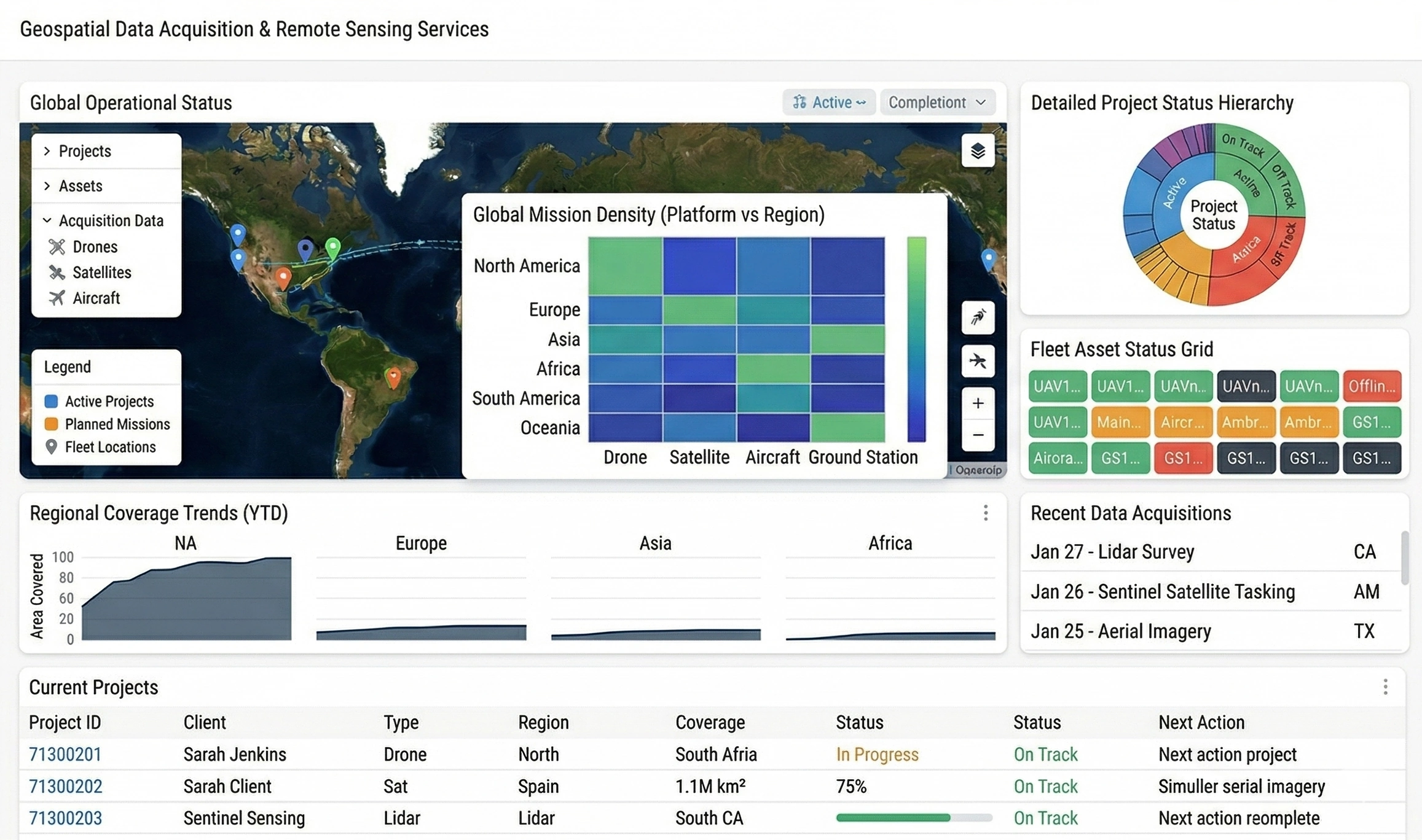
From Preset to InetSoft: Elevating Geospatial BI for Remote Sensing Operations
For geospatial data acquisition and remote sensing services providers, business intelligence is no longer a “nice to have” reporting layer. It is the operational cockpit for mission planning, sensor utilization, data product delivery, and SLA compliance. As data volumes grow and customer expectations tighten, the BI platform must keep pace with complex spatial analytics, multi-tenant delivery, and demanding security requirements.
Many organizations in this space began their analytics journey with cloud-hosted tools like Preset, attracted by quick setup and a familiar dashboarding paradigm. Over time, however, limitations around governance, customization, and integration with geospatial workflows can become friction points. This is the backdrop for one geospatial data acquisition and remote sensing services company’s decision to migrate from Preset to InetSoft’s business intelligence dashboard solution.
Why a Geospatial and Remote Sensing Company Outgrew Preset
The company’s core business revolves around planning and executing aerial and satellite data acquisition campaigns, processing raw imagery into analysis-ready products, and delivering those products to customers through portals and APIs. Their BI layer must serve multiple personas: operations managers, flight planners, data engineers, GIS analysts, and external clients.
Preset initially met basic needs: standard KPI dashboards, time-series views of acquisition progress, and simple filters for region, platform, and customer. But as the organization matured, several pain points emerged:
- Complex data modeling: The team needed more flexible semantic modeling to unify operational, financial, and geospatial metadata without overloading the data warehouse with dashboard-specific logic.
- Advanced customization: They required pixel-precise layouts for customer-facing portals, with branded themes and embedded views that behaved like native application components.
- Multi-tenant governance: Supporting dozens of customers with strict data isolation and role-based access control demanded more granular security and row-level filtering capabilities.
- Integration with existing stack: The company wanted tighter integration with Java-based services, on-premise data stores, and existing authentication mechanisms.
These requirements pushed the team to evaluate alternatives that could deliver enterprise-grade BI while still supporting agile development and rich geospatial use cases.

Why InetSoft Aligned Better with Geospatial BI Needs
InetSoft’s business intelligence platform appealed to the company for several reasons that resonated with both IT leadership and geospatial practitioners. At a high level, InetSoft offered a more flexible architecture, stronger embedding options, and robust security and governance features.
Data Access and Semantic Modeling
Remote sensing workflows often involve heterogeneous data sources: mission planning databases, sensor telemetry, object storage for imagery, order management systems, and external GIS services. InetSoft’s data access layer allowed the team to connect to relational databases, cloud warehouses, and web services while defining reusable data blocks and semantic views.
Instead of pushing all business logic into SQL or relying on dashboard-level hacks, the company could define curated data models that encapsulated acquisition status logic, coverage calculations, and SLA metrics. This separation of concerns made it easier for IT to manage complexity while giving analysts a consistent, governed layer to build on.
Embedding and White-Labeling for Customer Portals
A major differentiator for InetSoft was its strength in embedding and white-labeling. The company’s customer portal is a critical touchpoint where clients monitor acquisition progress, review coverage maps, and download deliverables. Dashboards needed to feel native, not like an iframe bolted onto the side.
InetSoft’s embedding APIs and theming capabilities allowed the team to:
- Apply custom branding: Match customer-specific color schemes, typography, and layout conventions.
- Control interactions: Drive filters and parameters from the host application, synchronizing map extents, date ranges, and project selections.
- Optimize performance: Tune caching and query strategies for high-traffic customer views without compromising internal analytics.
This level of control was difficult to achieve with Preset’s more standardized, SaaS-centric approach.

Security, Multi-Tenancy, and Governance
For a geospatial services provider, data isolation is non-negotiable. Customers must only see their own missions, AOIs, and deliverables, even when they share underlying infrastructure. InetSoft’s row-level security and role-based access control allowed IT to define policies once and apply them consistently across dashboards and data models.
The team implemented a multi-tenant pattern where customer identifiers and project scopes were enforced at the data layer, not just in the UI. This reduced the risk of misconfiguration and simplified audits. Integration with existing identity providers further streamlined user management and access provisioning.
Planning the Migration from Preset to InetSoft
Migrating BI platforms in a production environment that supports paying customers is not a trivial exercise. The company’s IT team approached the transition as a phased, controlled project with clear milestones and rollback options.
Inventory and Rationalization of Existing Dashboards
The first step was to inventory all Preset dashboards, charts, and data sources. Rather than blindly recreating everything, the team categorized assets into:
- Core operational dashboards: Mission status, acquisition backlog, sensor utilization, and SLA tracking.
- Customer-facing views: Project progress, coverage maps, and delivery status for each client.
- Ad hoc and legacy content: One-off analyses and outdated dashboards that could be retired or consolidated.
This rationalization exercise reduced clutter and ensured that only high-value content was targeted for migration.
Rebuilding Data Models in InetSoft
Next, the team focused on data modeling. Instead of replicating Preset’s data source definitions verbatim, they used the opportunity to design cleaner, more reusable semantic layers in InetSoft. Operational tables were joined with geospatial metadata, customer contracts, and SLA definitions to create comprehensive subject areas.
Calculations such as “percent coverage achieved,” “missions at risk,” and “on-time delivery rate” were defined centrally. This ensured consistency across dashboards and reduced the risk of metric drift between teams.
Dashboard Redesign with a Geospatial-First Mindset
While many Preset dashboards were functionally adequate, the team recognized that InetSoft’s richer layout and interaction capabilities justified a redesign. They adopted a geospatial-first approach, making maps the organizing element for many views.
For example, an acquisition operations dashboard now centers on an interactive map showing current and planned flight lines, color-coded by status. Supporting charts—such as mission counts by platform, backlog by region, and SLA risk indicators—are arranged around the map, all cross-filtered by spatial selection. This design better reflects how operations teams think and work.

Operational and IT Benefits Realized
After the migration, the company observed tangible benefits across both business and IT dimensions.
Improved Performance and Scalability
InetSoft’s architecture allowed the team to fine-tune query execution, caching, and data refresh strategies. High-traffic customer dashboards were backed by optimized views and incremental refreshes, while internal analytics could tolerate more exploratory queries. This balance improved perceived performance and reduced load on core databases.
Stronger Alignment Between IT and Geospatial Teams
The semantic modeling capabilities encouraged closer collaboration between IT, data engineers, and GIS analysts. Business logic for coverage, mission risk, and SLA compliance was documented and implemented centrally, reducing ambiguity. Analysts could build new dashboards faster, confident that they were using trusted metrics.
Enhanced Customer Experience and Differentiation
On the customer side, embedded InetSoft dashboards elevated the portal experience. Clients gained more intuitive, map-centric views of their projects, with responsive filters and branded layouts that matched contractual expectations. The company could also roll out new analytics products—such as historical trend analysis or predictive acquisition windows—without re-architecting the portal.

Key Takeaways for IT Leaders in Geospatial and Remote Sensing
For IT leaders supporting geospatial data acquisition and remote sensing services, the move from Preset to InetSoft illustrates a broader pattern: as organizations mature, they need BI platforms that can keep up with complex, domain-specific requirements.
The critical lessons from this migration include:
- Treat BI as part of the product: For customer-facing portals, dashboards are not just internal tools; they are part of the value proposition.
- Invest in semantic modeling: Centralized, reusable data models reduce technical debt and accelerate new analytics use cases.
- Prioritize security and multi-tenancy: In a multi-client environment, robust row-level security and governance are foundational, not optional.
- Design around geospatial workflows: For remote sensing, maps and spatial context should be first-class citizens in dashboard design.
By selecting a BI platform that aligns with these principles, geospatial and remote sensing organizations can transform their dashboards from static reports into dynamic, operational control centers—supporting better decisions, stronger customer relationships, and scalable growth.