Using Google Maps in a BI Dashboard or Visualization
InetSoft's business intelligence dashboarding software lets you chart data on a Google map for interactive data visualizations. Using the Google map API and InetSoft's script language, you can request a static map from Google to be the background of the chart you design in InetSoft's StyleBI application. Then you can plot your geocoded data from almost any data source based on latitude and longitude.
Add to your interactive dashboard selection lists, range sliders and a calendar selector, and you can build an efficient way to explore data in relation to geographic features such as as streets, buildings, and terrain features.
This gives you the ability to visualize data on a very local basis when using the standard boundary map files that come with InetSoft's charting engine and plotting data based on postal code or region isn't sufficient.

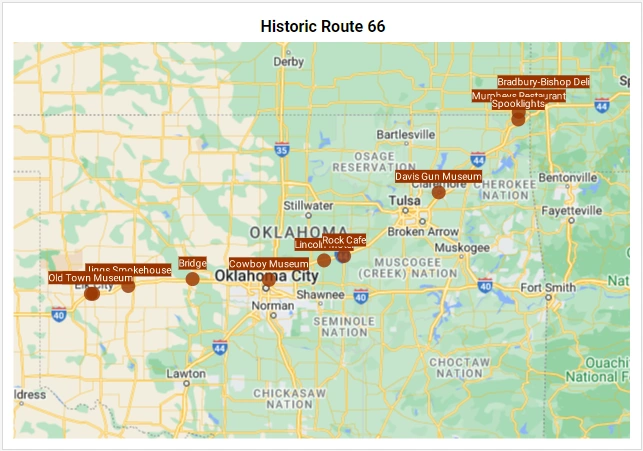
Example of a Google Map Dashboard
This example illustrates the interactive display of the locations of Wi-Fi hotspots in New York City. Multidimensional data can also be charted taking advantage of sizing, coloring, and shapes in order to make patterns apparent.

More Options When Using Google Maps
When choosing the kind of map image to use in your data visualization, you have all of the options made available from the Google API. Google's documentation page details the options and URL fetching syntax, and highlights are mentioned here.
- Map size - the image file can be as large as 1280x1280 pixels under the free usage license, and 2048x2048 pixels under the commercial license
- Zoom level - the detail shown on a map varies with the zoom level from between 0 (the lowest zoom level, in which the entire world can be seen on one map) to 21+ (in which individual buildings can be see) when using the default roadmap maps view
- Map type - the default view is the roadmap view, and other options are satellite, terrain, and hybrid
Frequently Asked Questions
What are the Google map licensing options?
If you are making the maps publicly visible free of charge and make less than 25,000 map requests a day, then you can take advantage of Google's free license. For use in a commercial application or for private enterprise use, you must contact Google about the Google Maps API for Business program. Of course, using InetSoft's commercial software requires separate licensing from InetSoft.
Can the maps have interactive zooming and panning?
No, you are only able to specifiy a static map for a given chart background.
Can Google map markers be used?
Yes, you can specify static balloon markers in the URL request to get the static map, but they cannot be changed dynamically.
Can street addresses be used to plot data?
No, InetSoft's charting engine requires latitude and longitude coordinates. Google provides a utlity to manually generate the coordinates for a given street address or famous location, and the Geocoding API for automated conversions.

How a Field Operations Company Does BI Data Visualizations on Google Maps
Among the many ways organizations have leveraged business intelligence (BI) to visualize data, few are as intuitively powerful as integrating analytics with Google Maps. Location-based data visualization can turn a complex spreadsheet into an interactive, decision-ready dashboard. One particularly interesting case is how a logistics and field operations company, GeoRoute Solutions, uses Google Maps-based BI dashboards to completely transform route optimization, workforce performance analysis, and customer experience monitoring.
The Business Context: The Challenge of Location-Heavy Data
GeoRoute Solutions managed hundreds of service technicians who traveled daily across a major metropolitan region to install, repair, or inspect customer equipment. The company was generating a vast amount of data: GPS pings, work order logs, fuel consumption records, and customer satisfaction scores. Each data source existed in a silo—vehicle tracking software, CRM, and ERP systems all held valuable but disconnected pieces of information.
Management had two problems. First, they lacked a single view of how geography affected performance metrics like response time, service cost, and customer ratings. Second, dispatchers were relying on static Excel reports to plan routes—a time-consuming process that ignored real-time traffic or cluster density. They needed dynamic visual analytics that could integrate live location data with business metrics in a way that everyone—from executives to technicians—could interpret instantly.

The Solution: Embedding BI Analytics into Google Maps
The company adopted a BI platform capable of geographic visualization and embedded Google Maps directly into their dashboard interface. The system mashed up data from multiple internal sources—fleet management, CRM, inventory tracking, and HR scheduling—and then layered it visually on a Google Map canvas. The resulting dashboard allowed users to see both operational metrics and geographic patterns in real time.
Each marker on the map represented a service job or technician, color-coded by performance metrics such as job completion rate or average resolution time. Data overlays highlighted areas with high demand, excessive travel times, or recurring issues. Heatmaps revealed service density, helping planners visualize where to allocate resources or open new regional hubs. Traffic layers, integrated from Google’s live data, provided contextual awareness of delivery delays or technician slowdowns.
Key Metrics Visualized on the Map
- Average Response Time by Zone: Color gradients on map polygons indicated average time-to-arrive in each ZIP code or neighborhood. Red zones meant service lag; green meant optimal efficiency.
- Technician Utilization: Real-time technician locations showed whether staff were evenly distributed or overloaded in specific regions. Dispatchers could rebalance assignments instantly.
- Fuel Cost per Route: Aggregating GPS data with fuel card transactions provided a clear visual of which routes were draining profitability.
- Customer Satisfaction Hotspots: Overlaid sentiment markers from post-service surveys helped identify areas where customers consistently rated poorly—often correlating with long travel times or high traffic density.
- Work Order Clustering: Google Maps clustering revealed patterns of high job volume, helping analysts pinpoint where to locate new storage depots or satellite offices.
Derived Metrics Created by the Mashup
By combining operational BI data with geospatial context, GeoRoute developed several new derived KPIs that were not visible before:
- Travel Efficiency Index (TEI): A ratio comparing the number of completed jobs per mile traveled. This metric helped evaluate both driver routing efficiency and scheduling optimization.
- Geo-Customer Lifetime Value (GCLV): Customer lifetime value segmented by geography, revealing which service territories were most profitable after accounting for travel costs and churn.
- Time-to-Resolution Gradient: A heatmap metric showing how far average completion times deviated from the company’s SLA target by area, turning service quality into a visual geography-driven insight.
- Predictive Service Density: An AI-driven layer projecting where demand would spike next week based on historical data, population trends, and seasonal patterns—displayed directly on the map.

The Impact of Visualization on Decision Making
Before implementing the Google Maps BI visualization, the company’s regional managers spent hours compiling static reports from spreadsheets. Afterward, they could open an interactive map and immediately spot inefficiencies. For example, they discovered that a cluster of delayed service calls correlated with a single highway bottleneck that technicians encountered daily. By reassigning technicians and reordering service zones, they reduced average travel time by 18% in one month.
Customer satisfaction scores also improved because dispatchers could reroute technicians in real time when delays occurred. Executives used the same dashboard to justify capital investments in a new field depot in a high-demand area, backed by visual proof that route density and service demand justified the cost. These were decisions that previously would have been driven by instinct; with mapped BI data, they were supported by evidence and easily communicated to stakeholders.
Expanding Use Cases Beyond Logistics
While the GeoRoute example focuses on service logistics, Google Maps visualizations extend to many industries. Retailers use them to correlate sales with store foot traffic and demographics. Utilities companies map outages and repair activity. Real estate developers overlay property valuations with neighborhood trends. Public health agencies visualize vaccination rates by location. The underlying power of Google Maps in BI lies in the human ability to grasp spatial relationships immediately—a heatmap of performance says more at a glance than a hundred rows of figures.
Technical Integration Details
The data mashup used APIs to connect the company’s SQL database, Google Ads (for lead sources), and CRM system into a BI tool capable of embedding Google Maps visual layers. Latitude and longitude data were derived automatically from customer addresses via Google’s Geocoding API. Dynamic filters allowed users to drill down by region, technician, or time period. The dashboard refreshed every five minutes, ensuring that field supervisors always had a live operational picture.
To handle performance, the company used server-side caching and clustering features from the BI platform to aggregate location data before visualization. Map layers were optimized using marker clustering and polygon simplification techniques to keep rendering smooth, even with tens of thousands of data points.

Why This Approach Works So Well
Integrating BI with Google Maps transforms the abstract into the tangible. Numbers alone can describe performance, but location-aware visualization reveals the “why.” You don’t just see that costs are higher—you see where they are higher. You don’t just know that satisfaction is dropping—you can see that it’s happening in specific geographic pockets correlated with distance or infrastructure.
This spatial perspective encourages action. Managers can zoom in, filter, and assign resources dynamically. Field teams can visualize their performance areas directly on their phones. Executives can communicate complex operational patterns in board presentations without showing a single spreadsheet.
The Broader Implications
As data volume and granularity grow, spatial BI becomes an essential layer for decision-making. Whether through Google Maps, Mapbox, or custom GIS integrations, organizations gain a new level of operational intelligence when they combine location data with business KPIs. For companies managing assets, customers, or personnel across physical spaces, this kind of mapping visualization isn’t a novelty—it’s the missing piece that connects the digital and physical worlds of business operations.
In the case of GeoRoute Solutions, Google Maps turned a reactive, fragmented workflow into a proactive, data-driven strategy. That’s the power of BI visualizations on a map: they make business performance visible not just in charts and numbers, but on the very landscape where it unfolds.